
Click name board above for home or choose from
the menu below
|
Station
Layout |
||||
|
|
|

|
Station Layout |
|
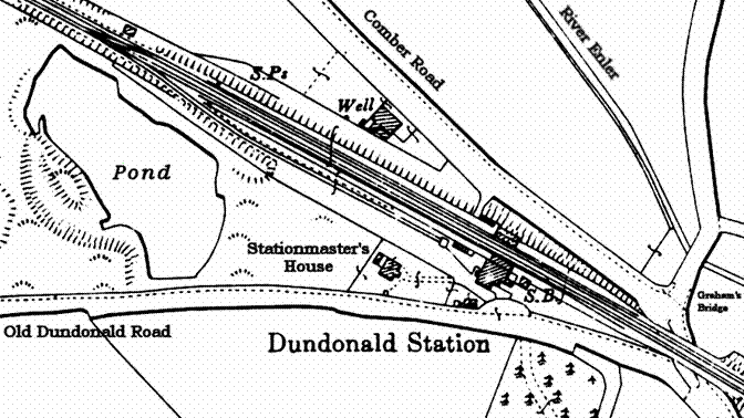
Where was Dundonald Station? Travelling by rail from
The pond to the west of the station
was a former quarry which was worked in the later part of the 19th
century. At one The good’s siding was later
supplemented with a short cattle beaching on the raised area shown above
between the pond and the siding. This was at the end of the lane beside the
siding for loading. There was most probably a ramp from the lane to the beaching
to facilitate the loading cattle etc. On the down (eastern) side
of the station, bridge number 64 carried the double track over the Comber
Road. This bridge was of trellised-girder construction resting on stone
abutments. Station layout The diagram below shows the
layout of the station buildings:
The subway was also known as
bridge number 63. (All over-bridges, under-bridges, foot-bridges and station
subways on the system were numbered from 1 to 215). The platforms at Dundonald
were of an equal length. Excluding the ramps at either end they were 646 feet
(197 metres) long. The signal box controlled a
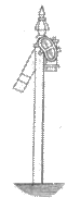
number of fixed Semaphore signals on the line either side of the station. The
form of signals used by the company had an arm on the left hand side of the
post. This arm was used for day signals. The normal position of the arm was
horizontal which indicated ‘DANGER’. When a train was free to pass, the arm
of the signal would fall indicating ‘ALL RIGHT’. At night a lamp was used
with red and green filters which moved over the lamp as the arm moved. Red indicated
‘DANGER’ and green ‘ALL RIGHT’. |
|
|
Home and starting Semaphore
signals, as shown to the left, were provided respectively at the entrance to
and exit from the station. On the up (western) side of the station these were
at the platform ends. On the down (eastern) side they were on the far side of
the bridge over the Comber Road. |
Distant signals were fixed
at some distance from the Home signals. The arms on these signals were
notched (also known as swallow-tailed) as shown to the right. |